About Kahoolawe
Interesting Places, Natural, Islands, Nature Reserves, Other Islands, Other Nature Conservation Areas
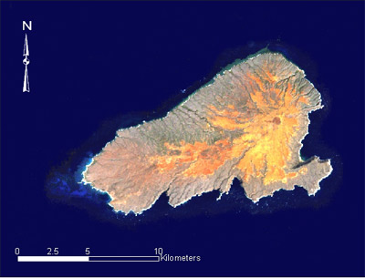
Kahoʻolawe (; Hawaiian: [kəˈhoʔoˈlɐve]) is the smallest of the eight main volcanic islands in the Hawaiian Islands. Kahoʻolawe is located about seven miles (11 km) southwest of Maui and also southeast of Lānaʻi, and it is 11 mi (18 km) long by 6.0 mi (9.7 km) wide, with a total land area of 44.97 sq mi (116.47 km2). The highest point on Kahoʻolawe is the crater of Lua Makika at the summit of Puʻu Moaulanui, which is about 1,477 feet (450 m) above sea level. Kahoʻolawe is relatively dry (average annual rainfall is less than 65 cm or 26 in) because the island's low elevation fails to generate much orographic precipitation from the northeastern trade winds, and Kahoʻolawe is located in the rain shadow of eastern Maui's 10,023-foot-high (3,055 m) volcano, Haleakalā. More than one quarter of Kahoʻolawe has been eroded down to saprolitic hardpan soil.